3-day hike
Skogar - Landmannalaugur
|
|
Location: |
starting point: Skogar, approximately 100 miles southeast of Reykjavik, on the southcoast |
|
Features: |
waterfalls, gorges, rivers, lake, hot springs, lava |
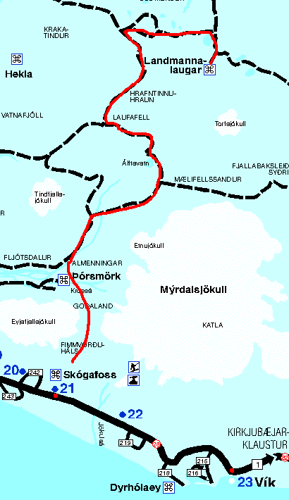 |
| the trail from Skogar to Landmannalaugur |
This trail is one of the most impressive trails I have ever hiked. Roughly 50 miles long it has all the things iceland is famous for: fantastic waterfalls, deep gorges, glaciers and icefields, beautiful lakes, lavafields and of course hot springs.
Depending on the weather, which is usually pretty nasty and wet, it'll take you at least three days for the whole distance. There are a few small cabins on the way where you can spend the night. I don't think they are always open, so don't count on it. But you can book it in advance to make sure you have the key. At the end of the peak season (end of August) there is a good chance that the cabins are open and you'll find a free place. Especially if the weather is very bad and stormy you will be greatful for NOT having to sleep in your tent (so did we).
We did the trail in three stages:
Skogar - Thorsmoerk, Thorsmoerk - Alftavatn, Alftavatn - Landmannalaugur.
|
|
1st day: Skogar-Thorsmoerk (15 miles)
|
 |
| Skogarfoss |
|
 |
|
waiting for Mike in the morning...
|
This is the most beautiful part if you like waterfalls, gorges and glaciers.The trail starts to the right of the waterfall with a steep climb on top. Then it follows the river which runs through a up to 70 meters deep gorge. |
Along the river there are lots of waterfalls, one better than the other. Eventually you'll cross the highest point in between the glaciers Myrdalsjoekull and Ejafjalla-joekull. Don't worry, it's clearly marked where you have to go, so you don't need heavy gear. From there you can already see the end of this day, thorsmoerk, a big valley with huge rivers. There is supposed to be a bridge somewhere to the left in the valley, where |
|
 |
|
 |
|
the gorge from top of a waterfall
|
|
Robert defenitely likes it!
|
 |
| yeah...that's a big help! |
you can walk to the other side, but we couldn't find it. You can of course try to cross the river but I bet it's no fun! Instead of that we just stoped the next highlandbus we saw and the busdriver got us safely to thorsmoerk (he didn't even charge a fee). |
|
2nd Day: Thorsmoerk - Alftavatn
|
There is nothing to say about this day, because the weather sucked big time! It was raining constantly and the wind almost drove us mad. We didn't even make it to the lake Alftavatn, but had to give up after 10 miles. Fortunately one of the cabins was open and we've been really very greatful to spend that night in a warm and dry place. |
|
3rd Day: Alftavatn - Landmannalaugur
|
 |
 |
| close to the volcano Hekla - ashes from the last eruption |
the beautiful lake Alftavatn
|
The most beautiful day of the tour but also the hardest one. Since we didn't get so far the other day, we still had 24 miles to go in one day. Unfortunately not entirely flat! The part from our cabin to the lake Alftavatn is the easy one. You'll cross a wide, almost level field with ashes from the volcano Hekla, which last erupted in 1991. It's like wandering on the moon.
After passing Alftavatn, the hard part is about to start. Almost two hours uphill, with a grade of at least 100 percent! You can probably imagine how we felt when we got on top. So maybe it's better to do the whole hike the other way around, starting in Landmannalaugur.
However...the panorama was worth the stress: |

|
|
panoramic view after the hard climb
|
After that you are already in the area of Landmannalaugur and just a couple of minutes later you defenitely know it: smells like sulfur. |
 |
 |
| Landmannalaugur - hot springs... |
...and small geysirs
|
This is probably one of the most fascinating areas in iceland. Behind every corner you hear the roaring sound of small geysirs and see the steam and the different colors. And it's up to you how close you wanna get. The only minuspoint is the bad smell of sulfur in the air. I don't think, anybody wants to camp here... |
 |
| the different colors of Landmannalaugur |
When you get out of the smell there is a point where you already can see the campsite of Landmannalaugur. But don't expect to get there soon...what you don't see is the lavafield you'll have to cross first. And this is hard work! It's like stairs going up and down in irregular steps...very painful, especially if you already hiked 22 miles the same day.
It's a good thing, that the campsite is close to a river, which in turn is heated up by hot springs. So, no matter how cold the air, the river is always worth a relaxing bath. |
I enjoyed this tour a lot, although next time I would do it rather in four days. It's less stress and there is more time to discover all the hidden places along the trail. |